
Set of Large Size 100 Practice Educational Blank Outline Maps of World/India/Continents Asia, Europe, AUS, N America, S America, Africa Political and Physical 11” x 9”
184 $

World Maps Coloring Book: World Regional Maps, Continents, countries of the world maps, World Geography, Outline and Blank Maps
386 $

Africa Classic, Tubed Wall Maps Continents: NG.PC622110 (Reference - Continents) (National Geographic Reference Map)
495 $

Map of the Continents 7 Poster Set
85 $

Crackles Big Size MDF Wood Paper Less Amazing World Continents Map 49 Pc Floor Jigsaw Puzzles
350 $

Mudpuppy Map Of Europe – 70 Piece Geography Puzzle with Country-Shaped Pieces and Iconic Landscapes Cultural Items And More
457 $
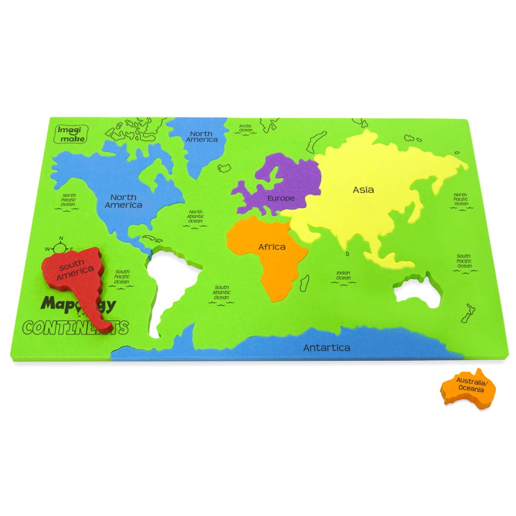
Imagimake Mapology Continents - Educational Toy and Learning Aid for Boys and Girls - Map Puzzle, Kid
96 $

Cool Owl Maps Africa Continent Wall Map Poster - Rolled Laminated (24"x32")
614 $

The Learning Journey: Lift & Learn Continents & Oceans - World Map Puzzle for Kids - Award Winning Toys
110 $

2 Pack - Laminated World Map Poster & USA Map Set - Equal Earth world map design shows continents at true relative size - US Map 18” x 29”
259 $

World Countries Maps Coloring Book - Continent Africa, Asia, Europe, Oceania, North and South America: Atlas of the World Coloring Maps with Countries Capitals Regions City Mountain River Sea
127 $

Europe Classic, Enlarged &, Laminated: Wall Maps Continents (National Geographic Reference Map)
1,669 $

South America Classic, Tubed: Wall Maps Continents (National Geographic Reference Map)
203 $

Teacher Created ResourcesContinents Set (9899)
679 $

CUT AND DRAW SMALL BOOK OF OUTLINE PRACTICE MAPS (100 ASSORTED MAPS) CONTAINS INDIA MAP, WORLD MAP AND CONTINENTS MAP Map – 30 September 2019
134 $
Teacher Created Resources TCR9689 Map Charts Set (Pack of 9)
259 $
World Map Continents, Animals & Oceans Kids Bedroom Rugs, 30 Animals, Continents, & Oceans, Play Mat Soft Rolled Fabric, Non-Slip Back (59 Pcs)
679 $

South America Classic, enlarged &, laminated: Wall Maps Continents (National Geographic Reference Map)
1,369 $

World Continents Map - Kids Childrens Wall Chart A3 (30cm x 42cm) Educational Childs Poster Art Print WallChart Kitchen & Home
62 $

Skillofun - MP-1 Map of Continent, Multi Color
53 $

Maps, the Oceans & Continents : Third Grade Geography Series: 3rd Grade Books - Maps Exploring The World for Kids (Children's Explore the World Books)
361 $

Navaris Cork Board World Map - Self-Adhesive Corkboard Continents for Wall to Pin, Plan and Document Travels - Includes 18 Cork Pieces and 10 Pins
380 $

Europe Classic, tubed: Wall Maps Continents (National Geographic Reference Map)
158 $

Imagimake Mapology World Map Puzzle | Educational Toys for Kids 5-7 | Puzzles for Kids Ages 4-8 | Map of The World | 6 Year Old Boy Gifts & Girl Gifts
391 $

Trend Continents Learning Charts Chart, Classroom Decor, 17" x 22", Set of 7
699 $

HomeEvolutionLarge Kids Educational Animal Landmarks World Map Peel & Stick Wall Decals Stickers Home Decor Art for Nursery
347 $

Melissa & Doug World Map Jumbo Jigsaw Floor Puzzle (33 pcs, 2 x 3 feet)
347 $

World Map Puzzle for Kids - 75 Piece - World Puzzles with Continents - Childrens Jigsaw Geography Puzzles for Kids Ages 4-8, 5, 6, 7, 8-10 Year Olds - Globe Atlas Puzzle Maps
457 $

Momo & Nashi United States & World Map Poster for Kids - 2 Pc - 24 x 16 Inch Waterproof USA & Map of the World Poster - for Wall Posters for Learning, Classroom, Education, Back to School Resources
410 $

Africa Continent Map, 1:8,000,000 (English, Spanish, French, Italian and German Edition)
169 $

Africa Jigsaw Puzzle - Map of Africa - Black History - Board Games - Jigsaw Puzzles - 100 Piece Puzzles - Continent Puzzle - Geography Puzzle - South Africa | Egypt | Nigeria | Ethiopia | Kenya
589 $

Trend The Continents Learning Chart, Classroom Decor, 17" x 22"
215 $

Outus Fully Laminated Preschool Educational Posters for Kids and Toddlers, Nursery Homeschool Pre-K Kindergarten (4 Pieces, World Map, USA Map, Solar System, Human Body)
369 $

Mudpuppy Map of the World Puzzle To Go, 36 Pieces, 12”x9” – Kids Ages 3+ - Colorful Map with Illustrations of Iconic Landmarks – Packaged in Travel-Friendly Drawstring Fabric Pouch –Perfect for Planes
281 $

Equal Earth World Map Poster - map design shows continents at true relative size. (LAMINATED, 18” x 29”)
236 $

Quarterhouse English-Spanish Educational Map Poster Set, Classroom Learning Materials for K-12 Students and Teachers, Double-Sided, Set of 7, 12 x 18 Inches, Extra Durable
724 $

merka Kids Placemat Kids World Map Kids Placemats for Dining Table World Atlas Map Countries Continents and Oceans Non-Slip Reusable Placemats
325 $

Maps, the Oceans & Continents : Third Grade Geography Series: 3rd Grade Books - Maps Exploring The World for Kids (Children's Explore the World Books)
281 $

Hadley Designs 4 Alphabet, Map of United States, World Map, Solar System, ABC Posters Toddlers Wall Decor, Planets For Kid, US Map Laminated Kindergarten Classroom Prek Homeschool Supplies 11x17
504 $

Little Wigwam World Map Chart - Tear-Resistant Educational Poster (24 x 17 inches)
259 $

CoolOwlMaps Europe Continent Wall Map Poster - Rolled Paper (32"x24")
170 $

World Map Laminated Poster -Double Side Educational Poster For Kids/Adults -18 x 24 inch Waterproof Map For Home Classroom
279 $

Jumbo Floor Puzzle for Kids,World Map Puzzle Jigsaw Geography Puzzles,48 Piece Globe Atlas Puzzle with Continents,United States Puzzle for Ages 3-5,Preschool Learning Toys Gift for 4-8 Years Old
221 $

Updated Peters Projection World Map | Laminated 36" x 24” Map | Developed by Arno Peters | Most Proportionally-Accurate Land Mass Depiction | Country Size & Scale is True, Unlike Most Maps | Major Countries, Cities, & Bodies of Water Labeled
1,159 $

Colorful World Map with Flags & Capitals + 50 Interesting Facts - XL Wall Art Poster for Home & Classroom - Educational for Kids & Adults
544 $

Evan-Moor Educational Publishers The World: Reference Maps & Forms Book (World & U.S. Maps) Paperback – Teacher's Edition, January 1, 2004
324 $

no/no Map Cage Continent North America Puzzle Picture Jigsaw Game Ornament Decoration
215 $

Antarctic Continent Waterproof Exploration Map 1:6.8M
152 $

Imagimake Mapology World Map Puzzle - Includes Country Flags & Capitals | Fun Jigsaw Puzzle Kids Ages 5-8 | Educational Toys for Ages 8-13 | Geography Gifts for Girls & Boys 5, 6, 7, 8, 9, 10, 11, 12
614 $

South America Wall Map Laminated GeoPolitical Edition by Swiftmaps A2 (42cm x 60cm)
356 $

South America Political & Physical Continent Map with Country Flags - 17" x 12" Laminated
187 $
Little Wigwam World Map "No Tear Guarantee" Educational Poster (60 x 42cm)
302 $

Faithful Prints Children's Animal Map of the World Poster Geography Print Wall Art for Kids Room (Blue) (A2 (420 x 594mm))
416 $

South America Wall Map Laminated GeoPolitical Edition by Swiftmaps A2 (42cm x 60cm)
121 $

Petit CollageFloor Puzzle, Our World, 24-Pieces – Large Puzzle for Kids, Completed Map Puzzle Measures 18” x 24” – Makes a Great Gift Idea for Ages 3+
447 $

EKDALI World Map and Its Countries | Learn about the Landmarks, Animals, Continents and Oceans | Educational posters for kids room |for ages - 2 to 99 Paper Print (Size Variant: A2 16 X 24 inches)
46 $

Edenpack World Map Poster for Children Large Illustrated Colourful Wall Map Poster for Kids with Countries and Animals Kids Educational Room Poster Decoration 76 x 43cm (World Map - Continents)
100 $
![2 Pack - World Map Poster & USA Map Chart [Purple] (LAMINATED, 18" x 29")](https://m.media-amazon.com/images/I/A1xGulRhAZS.jpg)
2 Pack - World Map Poster & USA Map Chart [Purple] (LAMINATED, 18" x 29")
110 $
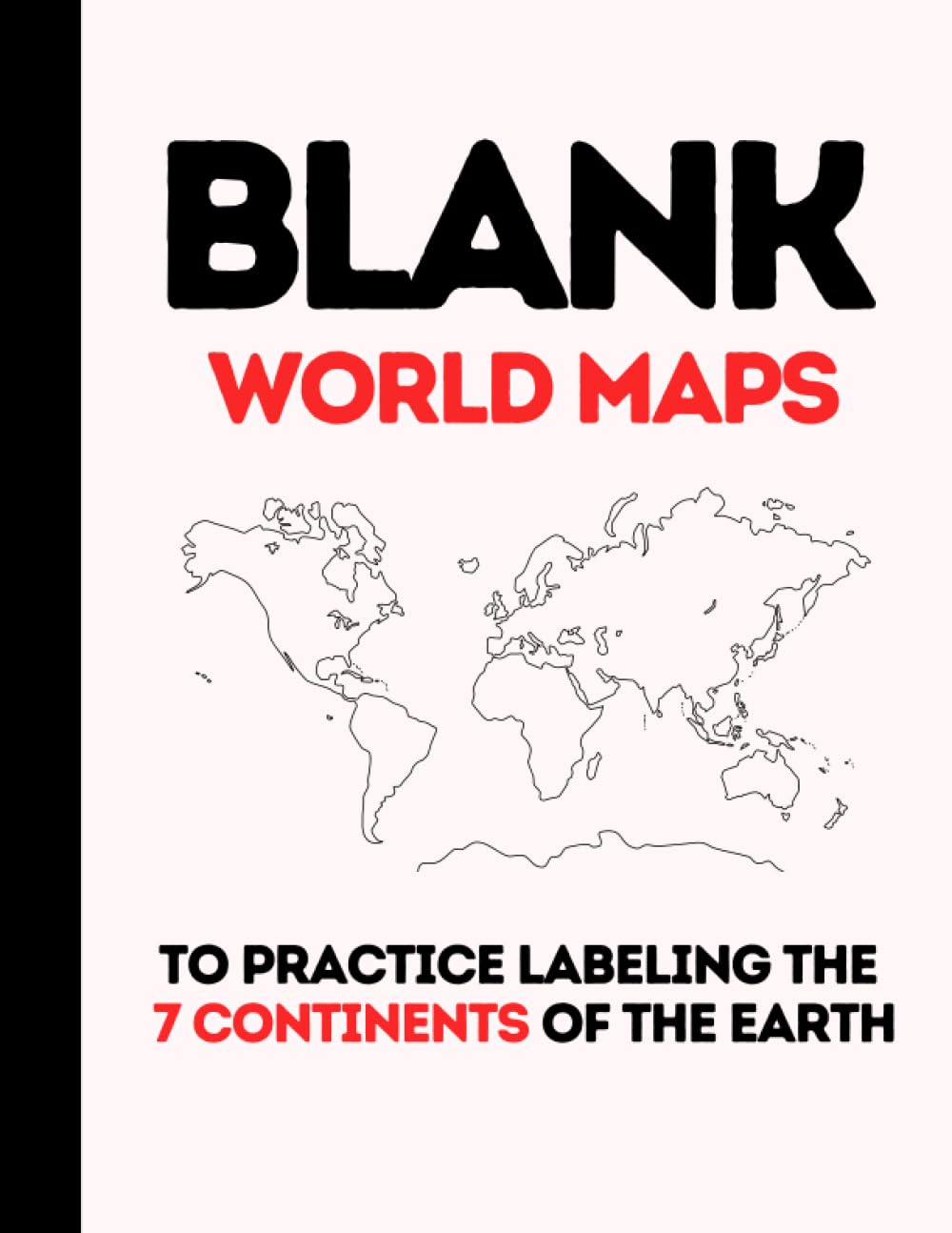
Blank World Maps: To Practice Labeling the 7 Continents of the Earth
59 $

7 Continents & 5 Oceans of The Earth Wooden Jigsaw Puzzle for Kids | 21 Puzzle Pieces | Learning & Educational Toy Gift for Boys & Girls Ages 3 Years and Above
504 $

North America Classic, Tubed: Wall Maps Continents (National Geographic Reference Map)
1,149 $

World Regional Maps Coloring Book: Maps of World Regions, Continents, World Projections, USA and Canada
323 $

Learning Resources Puzzle Globe - 14 Pieces, Ages 3+ Preschool Learning Toys for Boys and Girls, Earth Globe for Kids
869 $

World Map Coloring Book: Maps of the World Continents featuring Country Border, Capitals, Population figures and Empty Maps
84 $

USA and World map poster 2 pack for kids Laminated blue (Updated Fixed V2.0) Young N Refined (18x24)
169 $

The World Game - Fun Geography Board Game - Educational Game for Kids & Adults - Cool Learning Gift Idea for Teenage Boys & Girls, 2-5 players
764 $

Mappe Monde Nouvelle Antique World Map 1744 Vintage French Designed All Continents Countries Europe United States France Cartography Globe Earth Cool Wall Decor Art Print Poster 36x24
118 $

Swiftmaps World Premier Wall Map Poster Mural 24h x 36w
278 $

Africa Wall Map Laminated GeoPolitical Edition by Swiftmaps A2 (42cm x 60cm)
40 $

2 Pack - World Map for Kids + Blue Ocean USA Map (LAMINATED, 18" x 29")
347 $
![Africa Classic Map [Laminated] - Reference Map: Wall Maps Continents (National Geographic Reference Map)](https://m.media-amazon.com/images/I/81kPQ6oe0HL.jpg)
Africa Classic Map [Laminated] - Reference Map: Wall Maps Continents (National Geographic Reference Map)
809 $

Africa Classic, Enlarged &, Tubed: Wall Maps Continents (National Geographic Reference Map)
FREE

Europe Classic, Tubed
729 $

Australia Classic, Tubed
569 $
EKDALI World Map and Its Countries | Learn about the Landmarks, Animals, Continents and Oceans | Educational posters for kids room |for ages - 2 to 99 Paper Print (Size Variant: A1 24 X 33 inches)
345 $

Webby Wooden Educational India Political Map States Capital Learning, Board Puzzle for 4, 5, 6, 7, 8 Year Old Kids
213 $

Big Cut and Draw Book of Outline practice Maps Paperback – 1 January 2021
FREE

World Map Canvas Wall Art for Kids Room, Typical Animals on Continent Map of the World Canvas Prints for Children Education, Ready to Hang, 1" Deep, Waterproof Unknown Binding
1,069 $

United States Wall Map for Kids | States, Capitals & Pictures | Laminated durable poster 18" x 24" | Perfect for Classroom or Home
61 $
Get the App
